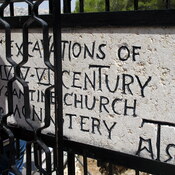
Vici.org
Il n'y a pas d'images. Télécharger une image.

Les environs:

Beit Sahur, Shepherds ChurchHerodionHerodion - lower cityHerodion - view from the top.Herodion - view from the top. 2006Herodion - view from the top.HerodionHerodionHerodium, sherds founded in the fortressHerodium, Synagogue I century ADMalha - Bronze Age NecropolisPool of SiloamChurch of St. John built over early Byzantine churchPlan of the ancient remainsPedestral HadrianTitus' triumphal processionJerusalem CardoMadaba mapJerusalem CardoMadaba mapJerusalem on the Madaba map.Jerusalem on the Madaba map.Ancient map of Jerusalem.Ancient map of Jerusalem.Ancient map of Jerusalem.Ancient map of Jerusalem behind the door.Golden gateMosaic floor from 5th century.Antonia FortressPool of Bethesda

Localisation:

  • PS, Bethlehem
  • geo:31.704348,35.207554
  • Précision ± 0-5 m.

Period or year:

  • 3xx~ / unknown

Classification:

  • Sanctuaire
  • Visible

Identificateurs:

  • vici:place=67627

Annotations

See:

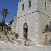
  1. Lucy O'Connor, “The Church of the Nativity, Bethlehem,” Architecture and Asceticism, accessed October 14, 2020, http://architectureandasceticism.exeter.ac.uk/items/show/202.

À proximité

BETHLEHEM

BETHLEHEM

Bethlehem, Milk Grotto

Chapel of the Milk Grotto.

Bethlehem Museum (1 km)

Betlehem Museum, Hebron Rd.