
No annotations have been added. Please add information about this place.

Location:
- Uzbekistan, Yangiyer
- geo:37.75407,67.60244
- Location ± 0-5 m.
Class:
- Archaeological observation
- visible
Identifiers:
- vici:place=97563
Annotations
Nearby
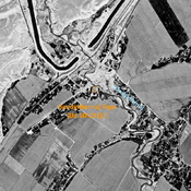
Bandykhansaj Tepe (Uz-SD-281) ? (5 km)
Late Iron Age settlement, on the right bank of the Bandykhansaj. Small site, studied by Rtveladze. Destroyed by modern urbanisation and cultivation, but possibly identified on Corona imagery.
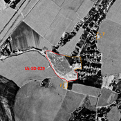
Anonymous settlement (Uz-SD-029) - ancient Darzangi ? (5 km)
Early, High Medieval and post-Mongol city-size settlement (50 ha). Mostly destroyed by Dzhelair modern town urbanisation. Studied by Arshavskaja and Rtveladze. Possible identification with medieval town of Darzangi / Darzanli.
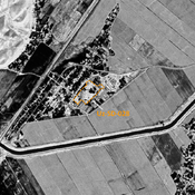
Unidentified site (6 km)
Probable archaeological site. Located with satellite imagery.