

MOGHADDAM Abbas & MIRI Negin (2003), Archaeological Research in the Mianab Plain of Lowland Susiana, South-Western Iran, Journal of the British Institute of Persian Studies (https://www.researchgate.net/publication/262117290_Archaeological_Research_in_the_Mianab_Plain_of_Lowland_Susiana_South-Western_Iran)

Location:
- Iran (Islamic Republic of), Sheykh Ḩoseyn
- geo:31.818657,48.875748
- Location ± 0-5 m.
Period or year:
- 10xx / 14xx
Class:
- Rural settlement
- invisible
Identifiers:
- vici:place=85816
Annotations
Nearby
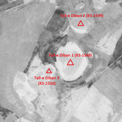
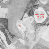
Tall-e Diban 1 (KS-1548)
Parthian, Sasanian and early medieval Islamic settlement (10,02 ha). Western part recently destroyed by agriculture.
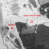
Unidentified site
Probable site. Leveled by agriculture, but visible on CORONA imagery. Part of the cluster of Tall-e Diban sites.
Tall-e Diban 2 (KS-1549)
Achaemenid, Parthian, Sasanian and early medieval Islamic settlement (3,11 ha). Recently destroyed by agriculture.