Vici.org
No images available yet. Please add images related to this place.

Surroundings:

SamosataSamosataSamosataThe south-east wall of the Roman settlement at SamosataSamsat ( Samosata ) - Aqueduct“totem pole” from Nevalı Çori.Nevalı Çori, Temple“totem pole” from Nevalı Çori

Location:

  • Türkiye, Kilisan
  • geo:37.504341,38.517864
  • Location uncertain

Period or year:

  • -5000~ / -1500~

Class:

  • City
  • invisible

Identifiers:

  • vici:place=68668

Annotations

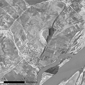
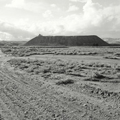
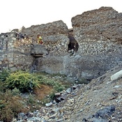
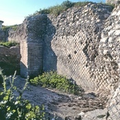
The excavations at Kurban Höyük were carried out by Dr. Leon Marfoe from 1980 till 1984. hree cultural layers were identified in this mound, 5000 - 3000  BC - Chalcolithic, 3000 - 2000 BC Early Bronze Age and  2000 - 1500 BC- MBA.

See:

  1. Kurban Höyük-http://www.tayproject.org/TAYages.fm$Retrieve?CagNo=2015&html=ages_detail_t.html&layout=web
  2. Town and Country in Southeastern Anatolia, Volume 2: The Stratigraphic Sequence at Kurban Höyük, Oriental Institute Publications (OIP), 1990
  3. L. Marfoe, “Kurban Höyük1982” Anatolian Studies33, 1983:pp.  253–254.

Nearby

Samosata (4 km)

The area of the ancient city flooded by an artificial lake.

Samosata (4 km)

Roman Legionary Fortress.The 5000-man Legion XVI Flavia was stationed in the city in the second century.

Samsat ( Samosata ) - Aqueduct (4 km)

The Roman aqueduct north of Samsat has been flooded by the waters of the lake formed behind the Atatürk Dam.


This object was added by Elżbieta on 2020-11-23. Last update by Elżbieta on 2020-11-23. Persistent URI: http://vici.org/vici/68668 . Download as RDF/XML, GeoJSON, KML.
Annotation available using the Creative Commons Attribution-ShareAlike 3.0 Unported license. Metadata available using the Creative Commons Public Domain Dedication, unless it is explicitly stated otherwise.

Vici.org partners:

Livius.org: articles on ancient history   Rijksmuseum van Oudheden