Vici.org
Il n'y a pas d'images. Télécharger une image.

Les environs:

Neolithic settlement, seventh millenium BCChurch of St. John built over early Byzantine churchPlan of the ancient remainsMalha - Bronze Age NecropolisAl-Jib, Late bronze potteryAl-Jib, Late bronze potteryMadaba mapJerusalem CardoJerusalem CardoAncient map of Jerusalem behind the door.Jerusalem on the Madaba map.Jerusalem on the Madaba map.Ancient map of Jerusalem.Ancient map of Jerusalem.Madaba mapAncient map of Jerusalem.Antonia FortressPool of BethesdaJerusalem BethesdaPedestral HadrianTitus' triumphal processionGolden gatePool of SiloamMosaic floor from 5th century.

Localisation:

  • Israël, Motsa ‘Illit
  • geo:31.794453,35.163776
  • Précision ± 0-5 m.

Period or year:

  • -750~ / unknown

Classification:

  • Sanctuaire
  • Visible

Identificateurs:

  • vici:place=61664

Annotations

See:

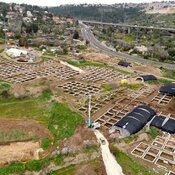
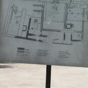
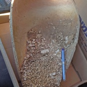
Temple and sacred vessels from Biblical times discovered at Tel Motza - https://mfa.gov.il/mfa/israelexperience/history/pages/temple_vessels_biblical_tel_motza_26-dec-2012.aspx


Musées associés

Archeologisch museum van Amman

Het oude archeologische museum van Jordanië.


À proximité

Motza

Neolithic settlement.

Castel (1 km)

A hilltop stronghold protecting the road to Jerusalem, constructed over the ruins of Roman and Crusader forts

Ein Karen, Saint John the Baptist Church (2 km)

St. John Ba Harim over Byzantine church.