Vici.org
Er zijn nog geen afbeeldingen met betrekking tot deze plaats toegevoegd.
Afbeelding toevoegen.

Omgeving:

Rough Castle FortCamelon FortLarbertWesterwood Fort

Locatie:

  • Verenigd Koninkrijk, High Bonnybridge
  • geo:55.998562,-3.850718
  • Locatie precies

Classificatie:

  • Weg
  • Niet zichtbaar

Identifiers:

  • vici:place=27502

Annotaties

Er zijn nog geen Nederlandstalige annotaties. Hier volgen annotaties in het Engels.
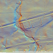
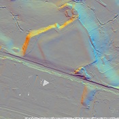
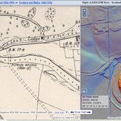
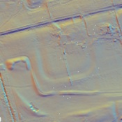
Millitary Way

Built 142-154

The Military Way was the road running behind the wall that connected all of the forts.  It has been identified in several places and marked on the British Ordnance Survey Maps.  This is one of these segments

Millitary Way

Built 142-154

The Military Way was the road running behind the wall that connected all of the forts.  It has been identified in several places and marked on the British Ordnance Survey Maps.  This is one of these segments


In de buurt

Rough Castle Baths

Rough Castle Baths

Rough Castle Fort

Rough Castle Fort

Roman

Roman encampent southwest of Fort and barracks.


Dit object is toegevoegd door Randal Gilbert op 2016-06-08. Laatst bewerkt door Randal Gilbert op 2016-06-16. Persistent URI: http://vici.org/vici/27502 . Download als RDF/XML, GeoJSON, KML.
Annotatie beschikbaar onder de Creative Commons Naamsvermelding-GelijkDelen 3.0 Unported-licentie. Metadata beschikbaar onder de Creative Commons Publiek Domein Verklaring, tenzij expliciet anders aangegeven.
Lijntracé bij dit punt door Randal Gilbert.

Vici.org partners:

Livius.org: articles on ancient history   Rijksmuseum van Oudheden