Vici.org
Keine Bilder von diesem Ort. Bitte, Bilder hochladen.

Umgebung:

Rough Castle FortCamelon FortLarbertWesterwood Fort

Lage:

  • Vereinigtes Königreich, High Bonnybridge
  • geo:55.998562,-3.850718
  • Lage ± 0-5 m.

Klassification:

  • Römerstraße
  • Unsichtbar

Identifiers:

  • vici:place=27502

Anmerkungen

Es gibt noch keine deutschsprachige Anmerkungen. Präsentiert wirden Anmerkungen auf English.
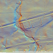
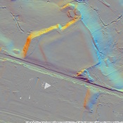
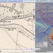
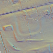
Millitary Way

Built 142-154

The Military Way was the road running behind the wall that connected all of the forts.  It has been identified in several places and marked on the British Ordnance Survey Maps.  This is one of these segments

Millitary Way

Built 142-154

The Military Way was the road running behind the wall that connected all of the forts.  It has been identified in several places and marked on the British Ordnance Survey Maps.  This is one of these segments


In der Nähe

Rough Castle Baths

Rough Castle Baths

Rough Castle Fort

Rough Castle Fort

Roman

Roman encampent southwest of Fort and barracks.