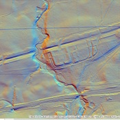
Vici.org
No images available yet. Please add images related to this place.

Surroundings:

Rough Castle FortCamelon FortLarbertWesterwood Fort

Location:

  • United Kingdom of Great Britain and Northern Ireland, High Bonnybridge
  • geo:55.998562,-3.850718
  • Location ± 0-5 m.

Class:

  • Road
  • invisible

Identifiers:

  • vici:place=27502

Annotations

Millitary Way

Built 142-154

The Military Way was the road running behind the wall that connected all of the forts.  It has been identified in several places and marked on the British Ordnance Survey Maps.  This is one of these segments
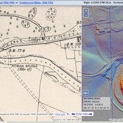
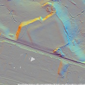

Nearby

Rough Castle Baths

Rough Castle Baths

Rough Castle Fort

Rough Castle Fort

Rough Castle

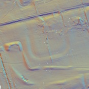
Roman encampent southwest of Fort and barracks.


This object was added by Randal Gilbert on 2016-06-08. Last update by Randal Gilbert on 2016-06-16. Persistent URI: http://vici.org/vici/27502 . Download as RDF/XML, GeoJSON, KML.
Annotation available using the Creative Commons Attribution-ShareAlike 3.0 Unported license. Metadata available using the Creative Commons Public Domain Dedication, unless it is explicitly stated otherwise.
Line tracing by Randal Gilbert.

Vici.org partners:

Livius.org: articles on ancient history   Rijksmuseum van Oudheden