
Il n'y a pas une annotation en français. Présenté est une annotation en Anglais.

Localisation:
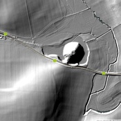
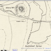
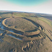
- Royaume-Uni, Winterbourne Monkton
- geo:51.437397,-1.841927
- Précision ± 0-5 m.
Classification:
- Observation
- Visible
Identificateurs:
- vici:place=97819
Annotations
À proximité
Avebury Monument (1 km)
Neolithic henge monument - stone circles dated to ca. 2600 BCE
Icknield Way (1 km)
Roman Rd.
West Overton (1 km)
Tumulus.