
Es gibt noch keine deutschsprachige Anmerkungen. Präsentiert wirden Anmerkungen auf English.

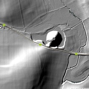
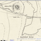
Lage:
- Vereinigtes Königreich, Winterbourne Monkton
- geo:51.437397,-1.841927
- Lage ± 0-5 m.
Klassification:
- Beobachtung
- Sichtbar
Identifiers:
- vici:place=97819
Anmerkungen
In der Nähe
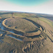
Avebury Monument (1 km)
Neolithic henge monument - stone circles dated to ca. 2600 BCE
Icknield Way (1 km)
Roman Rd.
West Overton (1 km)
Tumulus.