
Er zijn nog geen annotaties toegevoegd. Voeg een annotatie met betrekking tot deze plaats toe.
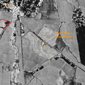
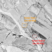
 Corona imagery (1970) - UZB-SD_1970_US (Oqlar 1)")
Omgeving:


Locatie:
- Oezbekistan, Oqlar
- geo:38.351376,67.834534
- Locatie precies
Classificatie:
- Archeologische waarneming
- Zichtbaar
Identifiers:
- vici:place=97318
Annotaties
In de buurt
Unidentified site
Probable archaeological site. Oval mound, visible on Corona imagery (1970), since leveled and destroyed by urbanisation.
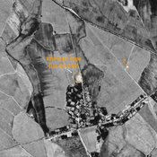
Kosh Tepe 1 (Uz-SD-495)
Yuezhi, Kushan, and early Medieval settlement (1 ha). Consisted of a citadal and a lower town, visible on Corona imagery (1970) with indistinct limits. Since destroyed entirely by modern cultivation. Fieldwork by Rtveladze, and surveyed by MAFOuz.
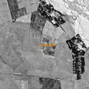
Anonymous site (Uz-SD-497) (1 km)
Pre-Mongol Medieval Islamic site (0,2 ha). Three small mounds visible on 1950 topographical map, already destroyed by 1970. Surveyed by MAFOuz.