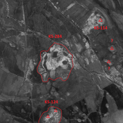
Vici.org
Keine Bilder von diesem Ort. Bitte, Bilder hochladen.

Umgebung:

Iran_Susiana_Unidentified (Boneh-ye ‘Alvān) - CORONA imageryIran_Susiana_Anonymous (KS-48) - CORONA imageryIran_Susiana_Unidentified (Chaghā Cheshmeh) - CORONA imageryIran_Susiana_Unidentified (Deylam-e ‘Olyā) - CORONA imageryIran_Susiana_Anonymous (KS-284) - CORONA imageryIran_Susiana_Anonymous (KS-077) - CORONA imageryIran_Susiana_Anonymous (KS-064) - CORONA ImageryIran_Susiana_Anonymous (KS-112) - CORONA imageryIran_Susiana_Anonymous (KS-606) - CORONA imageryIran_Susiana_Anonymous (KS-065) - CORONA imageryIran_Susiana_Anonymous (KS-117) - CORONA imageryIran_Susiana_Unidentified (Shahrak-e Enqelāb) - CORONA imageryIran_Susiana_Anonymous (KS-285) - CORONA ImageryIran_Susiana_Unidentified (Hādīshāh) - CORONA ImageryIran_Susiana_Anonymous (KS-327) - CORONA imagery

Lage:

  • Iran, Farrokh
  • geo:32.124107,48.465809
  • Lage ± 0-5 m.

Period or year:

  • -40xx / unknown

Klassification:

  • Bäuerliche Siedlung
  • Unsichtbar

Identifiers:

  • vici:place=86516

Anmerkungen

ALIZADEH, A. (1992), Prehistoric Settlement Patterns and Cultures in Susiana, Southwestern Iran - The Analysis of the F.G.L. Gremliza Survey Collection. University of Michigan Press (https://www.researchgate.net/publication/311558733_Prehistoric_Settlement_Patterns_and_Cultures_in_Susiana_Southwestern_Iran_The_Analysis_of_the_FGL_Gremliza_Survey_Collection)


In der Nähe

Unidentified site

Probable settlement. Cluster of mounds, partially destroyed by modern agriculture. Better visible on CORONA imagery.

Unidentified site

Probable settlement. Located with satellite imagery.

Boneh Seyed Taher (31) (1 km)

Bno dating information. Leveled by human activities.