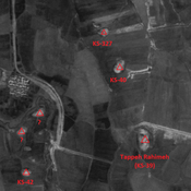
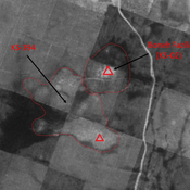
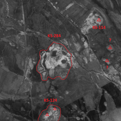
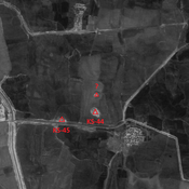
Vici.org
Il n'y a pas d'images. Télécharger une image.

Les environs:

Iran_Susiana_1968_Anonymous (KS-290 & 369) - CORONA imageryIran_Susiana_Anonymous (KS-108) - CORONA imageryIran_Susiana_Anonymous (KS-112) - CORONA imageryIran_Susiana_1968_Anonymous (KS-368 & 400) - CORONA imgeryIran_Susiana_Unidentified (Qal‘eh-ye Khalīl) - CORONA imageryIran_Susiana_Unidentified (Chaghā Cheshmeh) - CORONA imageryChoga MishIran_Susiana_1968_Anonymous (KS-397) - CORONA imageryIran_Susiana_Unidentified (Shalgehī-ye Pā’īn) - CORONA imageryIran_Susiana_Anonymous (KS-327) - CORONA imageryIran_Susiana_1968_Boneh Fazili (KS-02) & KS-394 - CORONA imageryIran_Susiana_Anonymous (KS-284) - CORONA imageryIran_Susiana_Unidentified (Deylam-e ‘Olyā) - CORONA imageryIran_Susiana_Anonymous (KS-117) - CORONA imageryIran_Susiana_Unidentified (Shahrak-e Enqelāb) - CORONA imagery

Localisation:

  • Iran, Belāvīyeh
  • geo:32.188484,48.521542
  • Précision ± 0-5 m.

Period or year:

  • -55xx / -40xx

Classification:

  • Habitat rural
  • Visible

Identificateurs:

  • vici:place=86317

Annotations

ALIZADEH, A. (1992), Prehistoric Settlement Patterns and Cultures in Susiana, Southwestern Iran - The Analysis of the F.G.L. Gremliza Survey Collection. University of Michigan Press (https://www.researchgate.net/publication/311558733_Prehistoric_Settlement_Patterns_and_Cultures_in_Susiana_Southwestern_Iran_The_Analysis_of_the_FGL_Gremliza_Survey_Collection)


À proximité

Tappeh Beladieh I (62)

No dating infirmation.

Unidentified site

Probable settlement. Located with satellite imagery.

Anonymous site (KS-406) (1 km)

Early Sasanian site. Destroyed by modern agriculture, but visible on CORONA imagery.