

MOGHADDAM Abbas & MIRI Negin (2003), Archaeological Research in the Mianab Plain of Lowland Susiana, South-Western Iran, Journal of the British Institute of Persian Studies (https://www.researchgate.net/publication/262117290_Archaeological_Research_in_the_Mianab_Plain_of_Lowland_Susiana_South-Western_Iran)

Location:
- Iran (Islamic Republic of), Deylam-e Jadīd
- geo:31.777407,48.89344
- Location ± 0-5 m.
Class:
- Archaeological observation
- invisible
Identifiers:
- vici:place=85845
Annotations
Nearby
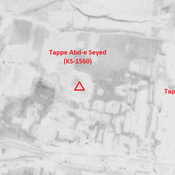
Tappe Abd-e Seyed (KS-1560)
Susa D period, Achaemenid and Sasanian settlement (2,2 ha).
Tappe Mosharahat (KS-1561)
No dating information. Cluster of mounds (0,98 ha).
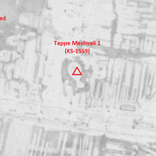
Tappe Meshvall 1 (KS-1559)
Achaemenid, Parthian and early medieval Islamic settlement (3,11 ha).