

MOGHADDAM Abbas & MIRI Negin (2003), Archaeological Research in the Mianab Plain of Lowland Susiana, South-Western Iran, Journal of the British Institute of Persian Studies (https://www.researchgate.net/publication/262117290_Archaeological_Research_in_the_Mianab_Plain_of_Lowland_Susiana_South-Western_Iran)

Location:
- Iran (Islamic Republic of), Bāstīyeh
- geo:31.759645,48.846439
- Location ± 0-5 m.
Period or year:
- 2xx / 14xx
Class:
- Vicus or canabae
- visible
Identifiers:
- vici:place=85831
Annotations
Nearby
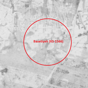
Basetiyeh (KS-1566)
Parthian and Sasanian city-size settlement (39,25 ha). Cluster of eroded mounds.
Aboo Amoud Nejat (KS-1558) (1 km)
Susa D period, Neo-Elamite, Achaemenid, Parthian, Sasanian, early and middle Islamic settlement (4,02 ha).
Unidentified site (2 km)
Probable settlement, recently ruined. Located with satellite imagery.