
HOPPER, Kristen Alicia (2017), The Gorgan Plain of northeast Iran - a diachronic analysis of settlement and land use patterns relating to urban, rural and mobile populations on a Sasanian frontier, Durham theses, Durham University (http://etheses.dur.ac.uk/12326/)

Location:
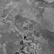
- Iran (Islamic Republic of), Şamadānī
- geo:37.311649,55.39341
- Location ± 0-5 m.
Period or year:
- -35xx / -2xx
Class:
- Rural settlement
- visible
Identifiers:
- vici:place=75907
Annotations
Nearby
Arab Buran 2 Tappeh (KH-28) (1 km)
Early Bronze Age and sasanian settlement. Almost completely destroyed by agriculture, but still visible on CORONA imagery (1969).
Qaleh Paras (KH-33) (1 km)
Parthian and medieval islamic settlement (Ilkhanid). badly damaged by agriculture, but still visible on CORONA imagery (1969).
Anonymous settlement (KH-27) (1 km)
No dating information. Extensive settlement linking several tappeh. Southern tappeh destroeyd by agriculture, but still visible on CORONA imagery (1969).