
HOPPER, Kristen Alicia (2017), The Gorgan Plain of northeast Iran - a diachronic analysis of settlement and land use patterns relating to urban, rural and mobile populations on a Sasanian frontier, Durham theses, Durham University (http://etheses.dur.ac.uk/12326/)
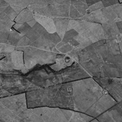
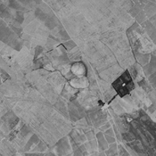
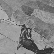
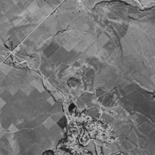
, Gorgan plain, Iran Corona imagery.")
Surroundings:

Location:
- Iran (Islamic Republic of), Moḩammadābād
- geo:37.324825,55.379646
- Location ± 0-5 m.
Period or year:
- 2xx / unknown
Class:
- Vicus or canabae
- visible
Identifiers:
- vici:place=75905
Annotations
Nearby
Sarhang Tappeh (KH-29) (1 km)
Early Bronze Age and Iron III & IV settlement.
Qaravol Tappeh Haji - Taji Gugjeh Tappeh (NTS-241) (2 km)
Bronze Age, Iron Age III & IV, achaemenid and sasanian settlement. Extensive site. Almost destroyed by urbanisation, but still visible on CORONA imagery (1969).
Anonymous settlement (KH-22) (2 km)
Late bronze age, Iron Age III & IV and achaemenid settlement. Outer town destroyed by agriculture, but still visible on CORONA imagery (1969).