
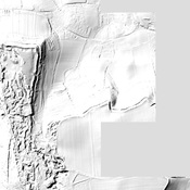
Roman Road from Aquis Sulis to Seaton

Localisation:
- Royaume-Uni, Stoke-sub-Hamdon
- geo:50.959892,-2.75575
- Précision ± 0-5 m.
Classification:
- Voie romaine
- Visible
Identificateurs:
- vici:place=19157
Annotations
The Fosse Way was one of the major Roman Roads in Britain, running from the coast near Seaton to Lincoln (Lindum)
This segment from the coast to Ilchester is shown in Margary as Road 5A.
À proximité
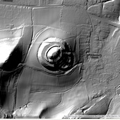
Ham Hill fort and villa rustica (1 km)
Ham Hill fort and villa rustica
Villa at Ham Hill (2 km)
Villa at Ham Hill (MONUMENT NO. 193155)
Montacute (2 km)
The Iron Age hill fort of Ham Hill, a large tribal fort of the Durotriges. The fort was conquered by the Roman Legio II Augusta sometime around 45 AD