


Es gibt noch keine deutschsprachige Anmerkungen. Präsentiert wirden Anmerkungen auf English.
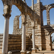
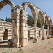
Large rectangular Roman temple on top of the tel, built 41-48 CE, and converted into a fortress in the mediaeval period will documented by Aliquot1. Taylor provides two photographs of the exterior in the 1960s2.
NB: There is some confusion as to the location of Gherra given on this map as being the late Roman/Ummayad fort of Anjar. Against Majdel Anjar is the probable name Chalcis for this site, but the two locations are very close, and there is confusion.
Referenzen
- ↑Julien Aliquot (2009). La Vie religieuse au Liban sous l'Empire romain: Békaa-Sud. Beyrouth : Presses de l’Ifpo, pp. 308-309, Section 70.
- ↑George Taylor (1967). The Roman Temples of Lebanon. Beirut : Dar el Mashreq Publishers. Plates 78, 79.