
GAUBE Heinz (1973), Die sudpersische Provinz Arragan - Kuh-Giluyeh von der arabischen Eroberung bis zur Safawidenzeit


Surroundings:

Location:
- Iran (Islamic Republic of), Meymand
- geo:31.142603,51.265415
- Location ± 0-5 m.
Period or year:
- 8xx / 11xx
Class:
- Vicus or canabae
- visible
Identifiers:
- vici:place=104705
Annotations
Nearby
Unidentified site (Meymand)
Probable archaeological site. Small mound, in the area of Meymand larger site, visible on Corona (1969) and KH9-Hexagon (1984) imagery. Since destroyed.
Meymand (G.2-15 - B.II)
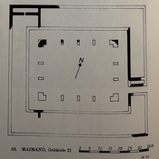
Medieval Islamic large square ruined building (65x70m) in Meymand larger site, surveyed by Gaube (1973) (building II), which he identifies as a caravanserail.
Meymand (G.2-15 - B.I)
Medieval Islamic housing squared ruined building, in the larger site of Meymand. Surveyed by Gaube (1968) (building I).