Es gibt noch keine deutschsprachige Anmerkungen. Präsentiert wirden Anmerkungen auf English.
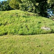
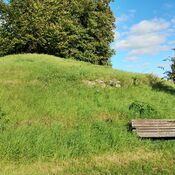
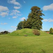
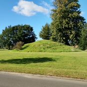
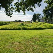
The site in Pipstorn Skov falls under the administrative responsibility of Arkæologi Sydfyn within the Faaborg-Midtfyn Municipality. The structures are classified as a Long Barrow (Langhøj) and a Dolmen or Passage Grave (Dysse eller Jættestue), both dated to the Stone Age (3950 – 2800 B.C.). The locality has been protected (Fredet) since 1937 or later, with documentation dating back to 1886 and boundary marking in 1893 and 1948.
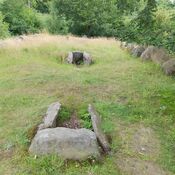
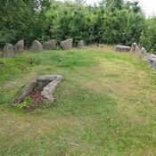
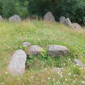
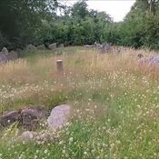
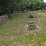
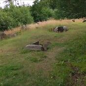
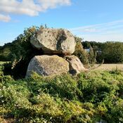
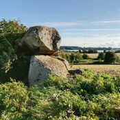
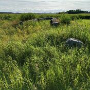
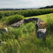
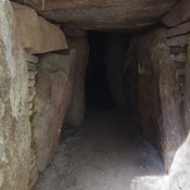
The primary archaeological feature described is a configuration of three joined long dolmens (Langdysser) oriented East-West (Ø-V).
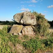
Northern Dolmen: Features the lintel (overliggeren) of 2 chambers.
Middle Dolmen: Contains 3 chambers, all oriented North-South (N-S):
The westernmost chamber has 1 stone at each end and 1 stone toward the West, 2 on the other side, but lacks a capstone.
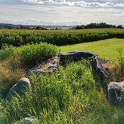
The middle chamber has 1 stone at the ends and on each side (possibly 2 in the West), and a small, somewhat displaced capstone that is partially overgrown by a mighty beech tree.
The third, easternmost chamber** is polygonal, constructed of 7 stones (2 in the West, 2 in the North, 2 in the East, and 1 in the South, where the chamber has its opening); it features an overturned capstone.
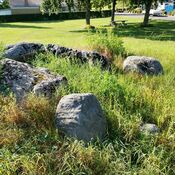
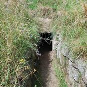
Southern Dolmen: Features 1 chamber oriented SSW-NNW, which is open toward the SSW. It is built of 3 stones and has a heavy, somewhat displaced capstone.
The Southern Dolmen measures approximately 1–1.2 x 7 x 16 meters.
It has 2–3 boundary stones (Randsten) toward the East, 12 toward the South, and 15 toward the North.
The Northern and Middle Dolmens together measure approximately 1–1.2 x 17 x 25 meters.
They share boundary stones with the Southern Dolmen toward the South, and appear to have 4–5 boundary stones toward the East and 8–9 toward the North.
Additionally, there are about 30 stones in an outer row and 11–12 stones in an inner row near the foot of the structure toward the West. These stones are likely a stone fence separating the Katterød and Diernisse land ownership areas, and were probably constructed using boundary stones removed from the site.
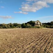
The site is described as overgrown with scattered large beech trees, beech scrub, and grass. In 1947, recommendations were made to place the lintel back in position, remove the large tree growing in one of the chambers, clear the beech scrub, and potentially expose the boundary stones.
The site has a history of documentation and investigation:
1886: Museal graphic or digital documentation and field survey by the National Museum.
1947: Museal field survey by the National Museum.
1953 & 2000: Museal restoration efforts occurred. The 2000 restoration was undertaken following the December 1999 storm.
2012: Periodical supervision of the protected locality was conducted by Museum Odense, confirming the ancient monument was found as described.
https://www.kulturarv.dk/fundogfortidsminder/Lokalitet/193004/
The site in Pipstorn Skov falls under the administrative responsibility of Arkæologi Sydfyn within the Faaborg-Midtfyn Municipality. The structures are classified as a Long Barrow (Langhøj) and a Dolmen or Passage Grave (Dysse eller Jættestue), both dated to the Stone Age (3950 – 2800 B.C.). The locality has been protected (Fredet) since 1937 or later, with documentation dating back to 1886 and boundary marking in 1893 and 1948.
The primary archaeological feature described is a configuration of three joined long dolmens (Langdysser) oriented East-West (Ø-V).
Northern Dolmen: Features the lintel (overliggeren) of 2 chambers.
Middle Dolmen: Contains 3 chambers, all oriented North-South (N-S):
The westernmost chamber has 1 stone at each end and 1 stone toward the West, 2 on the other side, but lacks a capstone.
The middle chamber has 1 stone at the ends and on each side (possibly 2 in the West), and a small, somewhat displaced capstone that is partially overgrown by a mighty beech tree.
The third, easternmost chamber** is polygonal, constructed of 7 stones (2 in the West, 2 in the North, 2 in the East, and 1 in the South, where the chamber has its opening); it features an overturned capstone.
Southern Dolmen: Features 1 chamber oriented SSW-NNW, which is open toward the SSW. It is built of 3 stones and has a heavy, somewhat displaced capstone.
The Southern Dolmen measures approximately 1–1.2 x 7 x 16 meters.
It has 2–3 boundary stones (Randsten) toward the East, 12 toward the South, and 15 toward the North.
The Northern and Middle Dolmens together measure approximately 1–1.2 x 17 x 25 meters.
They share boundary stones with the Southern Dolmen toward the South, and appear to have 4–5 boundary stones toward the East and 8–9 toward the North.
Additionally, there are about 30 stones in an outer row and 11–12 stones in an inner row near the foot of the structure toward the West. These stones are likely a stone fence separating the Katterød and Diernisse land ownership areas, and were probably constructed using boundary stones removed from the site.
The site is described as overgrown with scattered large beech trees, beech scrub, and grass. In 1947, recommendations were made to place the lintel back in position, remove the large tree growing in one of the chambers, clear the beech scrub, and potentially expose the boundary stones.
The site has a history of documentation and investigation:
1886: Museal graphic or digital documentation and field survey by the National Museum.
1947: Museal field survey by the National Museum.
1953 & 2000: Museal restoration efforts occurred. The 2000 restoration was undertaken following the December 1999 storm.
2012: Periodical supervision of the protected locality was conducted by Museum Odense, confirming the ancient monument was found as described.
https://www.kulturarv.dk/fundogfortidsminder/Lokalitet/193004/

")
")
")

")
")
")