
No annotations have been added. Please add information about this place.

Location:
- Uzbekistan, Yangiqishloq
- geo:37.687748,67.532417
- Location ± 0-5 m.
Class:
- Archaeological observation
- invisible
Identifiers:
- vici:place=97565
Annotations
Nearby
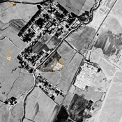
Unidentified site
Probable archaeological site. Mound visible on Corona imagery (1970), since destroyed by modern cultivation.
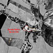
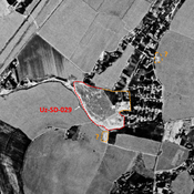
Arpapaja Tepe (Uz-SD-025) (3 km)
Kushan and High Medieval settlement. Studied by Rtveladze and Arshavskaja.
Unidentified site (3 km)
Probable settlement. Located with satellite imagery.