


Il n'y a pas d'annotations. Ajouter une note.

Localisation:
- Ouzbékistan, Jayilma
- geo:38.032681,67.774834
- Précision ± 0-5 m.
Classification:
- Observation
- Visible
Identificateurs:
- vici:place=97544
Annotations
À proximité
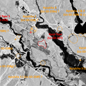
Unidentified site
Probable archaeological site. Small mound, part of a formally larger urban area, visible on Corona imagery.
Unidentified site
Probable archaeological site. Part of a larger site, which extends in all directions, with indistinct limits visible on Corona imagery (1970).
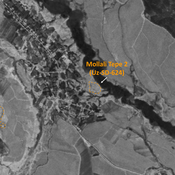
Unidentified site (1 km)
Probable settlement. Located with satellite imagery.