


Il n'y a pas d'annotations. Ajouter une note.

Localisation:
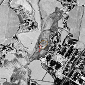
- Ouzbékistan, Garmatepa
- geo:37.988243,67.817131
- Précision ± 0-5 m.
Classification:
- Observation
- Visible
Identificateurs:
- vici:place=97541
Annotations
À proximité
Bul'bul Tepe (Uz-SD-185)
Early Medieval settlement (1 ha). Square site, with a citadel in its southern corner. Studied by Arshavskaja & Rtveladze, and MAFOuz.
Unidentified site
Probable settlement. Located with satellite imagery.
Unidentified site (1 km)
Probable archaeological site. Small square mound, visible on Corona imagery (1970), since leveled and destroyed by urbanisation.