


STRIDE, S. (2004), La Géographie archéologique de la province du Surkhan Darya (Bactriane du Nord, Ouzbekistan du Sud). Unpublished dissertation at the Université panthéon-Sorbonne (Paris), 5 vols. ( https://sirisacademic.academia.edu/SebastianStride?swp=tc-au-44230952 )
")
Location:
- Uzbekistan, Denov
- geo:38.276264,67.891121
- Location ± 0-5 m.
Period or year:
- 15xx /
Class:
- Building (other)
- visible
Identifiers:
- vici:place=97066
Annotations
Nearby
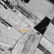
Anonymous site (Uz-SD-039) ?
Early Medieval settlement (0,19 ha). Uncertain location and possibly destroyed, though possible identification on Corona imagery. Studied by Arshavskaja & Rtveladze.
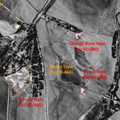
Bekovkij Kala (Uz-SD-374)
Late Bronze Age (?), Kushan, early Medieval (?) and pre-modern circular fortress (2 ha), partially destroyed in 1970 during a flood of the Kyzylsu. Studied by Pugachenkova and Rtveladze. Uncertainties about the datation.
Buradorlik Kabriston (Uz-SD-287)
Kushan settlement. Elevation (0,5 ha) in the north-western corner of the modern cemetery ; but exact perimeter of the site unknown. Studied by Rtveladze.