


STRIDE, S. (2004), La Géographie archéologique de la province du Surkhan Darya (Bactriane du Nord, Ouzbekistan du Sud). Unpublished dissertation at the Université panthéon-Sorbonne (Paris), 5 vols. ( https://sirisacademic.academia.edu/SebastianStride?swp=tc-au-44230952 )
")
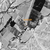
Location:
- Uzbekistan, Yangiobod
- geo:38.215008,67.922462
- Location ± 0-5 m.
Period or year:
- 10xx / 11xx
Class:
- Building (other)
- visible
Identifiers:
- vici:place=96971
Annotations
Nearby
Khasan Tepe (Uz-SD-078)
Kushan and High Medieval settlement. Remains of structures, already damaged when studied by Arshavskaja & Rtveladze, now entirely destroyed by modern construction. Complementary analysis by MAFOuz.
Kul' Tepe (Uz-SD-397) (1 km)
Medieval Islamic settlement. Large circular site, visible on Corona imagery (1970), since destroyed by modern cultivation. Ceramic studies by MAFOuz.
Surnai Tepe (Uz-SD-074) (1 km)
Hgih and Late Medieval settlement. Small tepe (0,3), studied by Arshavskaja & Rtveladze, and MAFOuz.