
STRIDE, S. (2004), La Géographie archéologique de la province du Surkhan Darya (Bactriane du Nord, Ouzbekistan du Sud). Unpublished dissertation at the Université panthéon-Sorbonne (Paris), 5 vols. ( https://sirisacademic.academia.edu/SebastianStride?swp=tc-au-44230952 )
 - UZB-SD_1970_Munchak Tepe 210")
Surroundings:

Location:
- Uzbekistan, Hurriyat
- geo:37.893623,67.658134
- Location ± 0-5 m.
Period or year:
- 8xx? / 12xx?
Class:
- Vicus or canabae
- visible
Identifiers:
- vici:place=96734
Annotations
Nearby
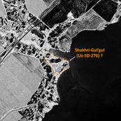
Shakhri-Gul'gul (Uz-SD-276) ? (2 km)
Kushan settlement, later reoccupied in post-Mongol medieval times. Studied by Pugachenkova & Rtveladze. Already damaged by riverine erosion of the Akdzharsaj by 1976, since then destroyed by urbanisation. Possible identification on Corona imagery.
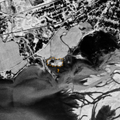
Unidentified site (3 km)
Probable archaeological site, badly damaged by dam reservoir. Located with satellite imagery.
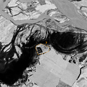
Jakhshibaj Tepe (Uz-SD-219) (4 km)
Kushan and early Medieval settlement. Badly damaged by modern reservoir. Fieldwork by Al'baum (1962) and Nil'sen (1966).