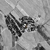
STRIDE, S. (2004), La Géographie archéologique de la province du Surkhan Darya (Bactriane du Nord, Ouzbekistan du Sud). Unpublished dissertation at the Université panthéon-Sorbonne (Paris), 5 vols. ( https://sirisacademic.academia.edu/SebastianStride?swp=tc-au-44230952 )
Localisation:
- Ouzbékistan, Yangiobod
- geo:38.200584,67.904762
- Précision ± 0-5 m.
Period or year:
- 6xx / 11xx
Classification:
- Habitat rural
- Invisible
Identificateurs:
- vici:place=96643
Annotations
Il n'y a pas une annotation en français. Présenté est une annotation en Anglais.
STRIDE, S. (2004), La Géographie archéologique de la province du Surkhan Darya (Bactriane du Nord, Ouzbekistan du Sud). Unpublished dissertation at the Université panthéon-Sorbonne (Paris), 5 vols. ( https://sirisacademic.academia.edu/SebastianStride?swp=tc-au-44230952 )
À proximité
Unidentified site
Probable settlement, consiting of a north-western citadel and a lower town. Badly damaged and built upon by modern housing. Better visible on Corona imagery (1970).
Karaul Tepe (Uz-SD-064)
Kushan and pre-Modern possible fort. Rectangular site (0,4 ha). Modern russian cemetery on top. Studied by Arshavskaja & Rtveladze, and MAFOuz.
Kurgancha Tepe (Uz-SD-391)
Pre-Mongol Medieval Islamic settlement. Small site, destroyed before 1963. Ceramic studies by MAFOuz.