
STRIDE, S. (2004), La Géographie archéologique de la province du Surkhan Darya (Bactriane du Nord, Ouzbekistan du Sud). Unpublished dissertation at the Université panthéon-Sorbonne (Paris), 5 vols. ( https://sirisacademic.academia.edu/SebastianStride?swp=tc-au-44230952 )
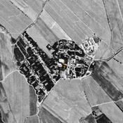
 Corona imagery (1970) - UZB-SD_1970_Jarim Tepe - Turmalak Tepe (076 and 086)")
Surroundings:


Location:
- Uzbekistan, Yangiobod
- geo:38.200584,67.904762
- Location ± 0-5 m.
Period or year:
- 6xx / 11xx
Class:
- Rural settlement
- invisible
Identifiers:
- vici:place=96643
Annotations
Nearby
Unidentified site
Probable settlement, consiting of a north-western citadel and a lower town. Badly damaged and built upon by modern housing. Better visible on Corona imagery (1970).
Karaul Tepe (Uz-SD-064)
Kushan and pre-Modern possible fort. Rectangular site (0,4 ha). Modern russian cemetery on top. Studied by Arshavskaja & Rtveladze, and MAFOuz.
Kurgancha Tepe (Uz-SD-391)
Pre-Mongol Medieval Islamic settlement. Small site, destroyed before 1963. Ceramic studies by MAFOuz.