
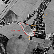
No annotations have been added. Please add information about this place.

Location:
- Uzbekistan, Kaptugay
- geo:37.714676,67.514465
- Location ± 0-5 m.
Class:
- Archaeological observation
- visible
Identifiers:
- vici:place=96047
Annotations
Nearby
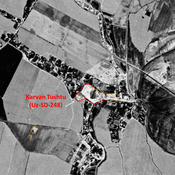
Karvan Tushtu (Uz-SD-248)
Also known as Katta Tepe. Kushan settlement (2 ha). Partially destroyed in 1970 already. Studied by Rtvealdze and Khakimov.
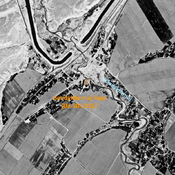
Unidentified site (3 km)
Probable archaeological site. Mound visible on Corona imagery (1970), since destroyed by modern cultivation.
Unidentified site (3 km)
Probable archaeological site. Mound visible on Corona imagery (1970), since destroyed by modern cultivation.