
Il n'y a pas une annotation en français. Présenté est une annotation en Anglais.

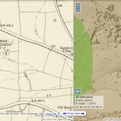
Localisation:
- Royaume-Uni, Lower Slaughter
- geo:51.905716,-1.747471
- Précision ± 0-5 m.
Period or year:
- 1xx? / unknown
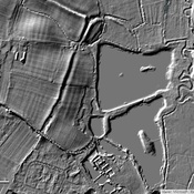
Classification:
- Habitat rural
- Invisible
Identificateurs:
- vici:place=92043
Annotations
À proximité
Salmonsbury Camp (2 km)
Iron Age fortified enclosure known as Salmonsbury Camp
Bourton-on-the-Water Settlement (2 km)
Settlement
St Mary's Church (2 km)
Roman burials, medieval settlement remains and a later ditched enclosure east of St Mary's Church