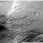
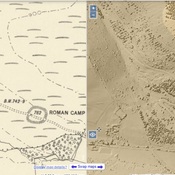
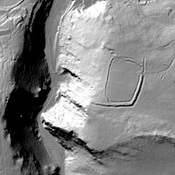
Vici.org

Surroundings:

Roman lead mines at CharterhouseIscalis FortletIscalis VicusRoman RdWestbury CampAmphitheatre IscalisTynings FarmBurrington CampMarchey FarmMap of earthworks at Maesbury Camp, Somerset

Location:

  • United Kingdom of Great Britain and Northern Ireland, Priddy
  • geo:51.271889,-2.660717
  • Location ± 0-5 m.

Class:

  • Archaeological observation
  • visible

Identifiers:

  • vici:place=92013

Annotations


Nearby

Villa at Priddy (1 km)

Villa at Priddy (MONUMENT NO. 197734)

Charterhouse (4 km)

Roman lead mines at Charterhouse

Iscalis Fortlet (4 km)

Iscalis Fortlet


This object was added by Ludwinski on 2023-11-21. Last update by Ludwinski on 2023-11-21. Persistent URI: http://vici.org/vici/92013 . Download as RDF/XML, KML.
Annotation available using the Creative Commons Attribution-ShareAlike 3.0 Unported license. Metadata available using the Creative Commons Public Domain Dedication, unless it is explicitly stated otherwise.

Vici.org partners:

Livius.org: articles on ancient history   Rijksmuseum van Oudheden