
Il n'y a pas d'annotations. Ajouter une note.

Localisation:
- Iran, Mīāngarān-e Soflá
- geo:31.881329,49.814095
- Précision ± 0-5 m.
Classification:
- Observation
- Visible
Identificateurs:
- vici:place=86221
Annotations
À proximité
Anonymous settlement (IS-8269-5892) (1 km)
Susa I settlement (?). Surveyed in 1979, but probably destroyed by modern agriculture.
Tagh-e Tavileh (6 km)
Seljuk and Ilkhanid fortified settlement.
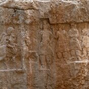
Hung-e Yar-i Alivand (6 km)
Parthian rock relief