Es gibt noch keine deutschsprachige Anmerkungen. Präsentiert wirden Anmerkungen auf English.
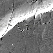
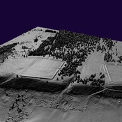
These coordinates mark the start of visible remains of the road connecting the Roman fort at Malton with the coast near Whitby. The raised central foundation can be followed North East.
These coordinates mark the start of visible remains of the road connecting the Roman fort at Malton with the coast near Whitby. The raised central foundation can be followed North East.
These coordinates mark the start of visible remains of the road connecting the Roman fort at Malton with the coast near Whitby. The raised central foundation can be followed North East