Es gibt noch keine deutschsprachige Anmerkungen. Präsentiert wirden Anmerkungen auf English.
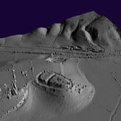
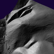
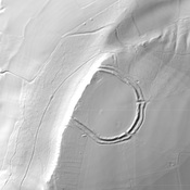
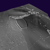
The building at Acton Scott, on Wenlock Edge south of Church Stretton, lies on a south-facing slope above a stream. The rectangular building was aligned precisely east-west, and appears to have had later additions to its western end. It is probable that the building originated as an 'aisled barn', and was later part-converted into a habitable dwelling. A small bath-house was incorporated within the south-west corner of the building (and/or added on to it; the actual building sequence of the structure is very complicated).
Given the proximity of the Romano-British lead-mining complex at Linley, which lies about 4 miles to the west, and the fact that there are no other substantial Romano-British buildings within some twenty miles or so, it is very likely that the villa building here at Acton Scott is associated in some mannner with the production of lead; perhaps being the official residence of the procurator in charge of the mine, removed away from the noise and pollution of the production centre itself, and placed beside a major north-south route ('Watling Street West'; Margary#6b). There was a Roman auxiliary fort situated about 3 miles to the south along this road at Stretford Bridge1.
See
- The Roman Villa - An Historical Introduction by John Percival (B.C.A., London, 1976) p.103;
- The Cornovii by Graham Webster (rev. ed., Sutton, London, 1991);
Referenzen
- ↑RBO: Acton Scott