
Er zijn nog geen annotaties toegevoegd. Voeg een annotatie met betrekking tot deze plaats toe.

Omgeving:
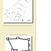

Locatie:
- Israël, Bet Shemesh
- geo:31.708673,35.024673
- Locatie precies
Period or year:
- -5x / unknown
Classificatie:
- Archeologische waarneming
- Zichtbaar
Identifiers:
- vici:place=63413
Annotaties
In de buurt
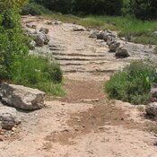
Caesar Way
Roman ancient road ascending from the valley of Elah. This road was part of the Roman road from the coast city of Ashkelon, via Beit-Guvrin, to Bethlehem and Jerusalem. Sections of the Roman road, named "Caesar Way", can be seen along the modern road, c
Khirbet el-Khan - Horvat Hanot (2 km)
Church dates to 6th century Mosaic inscription, early Byzantine period.
Bayt Nattif - Beit Nattif (3 km)
Ancient Jewish settlements of Judaea