
No annotations have been added. Please add information about this place.

Surroundings:
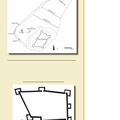

Location:
- Israel, Bet Shemesh
- geo:31.708673,35.024673
- Location ± 0-5 m.
Period or year:
- -5x / unknown
Class:
- Archaeological observation
- visible
Identifiers:
- vici:place=63413
Annotations
Nearby
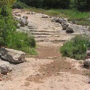
Caesar Way
Roman ancient road ascending from the valley of Elah. This road was part of the Roman road from the coast city of Ashkelon, via Beit-Guvrin, to Bethlehem and Jerusalem. Sections of the Roman road, named "Caesar Way", can be seen along the modern road, c
Khirbet el-Khan - Horvat Hanot (2 km)
Church dates to 6th century Mosaic inscription, early Byzantine period.
Bayt Nattif - Beit Nattif (3 km)
Ancient Jewish settlements of Judaea