
Il n'y a pas une annotation en français. Présenté est une annotation en Anglais.

Localisation:
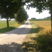
- Allemagne, Unterirsingen
- geo:48.042568,10.637695
- Précision ± 0-5 m.
Period or year:
- 50 / unknown
Classification:
- Habitat rural
- Invisible
Identificateurs:
- vici:place=57678
Annotations
À proximité
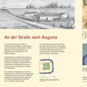
Straße Irsingen (1 km)
Straße
Bestattungsplatz (1 km)
Bestattungsplatz
Milestone Türkheim (CIL 17-04-01, no. 044) (2 km)
Milestone Türkheim (CIL 17-04-01, no. 044), see http://oracle-vm.ku-eichstaett.de:8888/epigr/epieinzel_en?p_belegstelle=CIL+17-04-01,+00044. Data from http://francia.ahlfeldt.se/