Vici.org

Surroundings:

Herodion - view from the top. 2006Herodion - view from the top.HerodionHerodion - lower cityHerodion - view from the top.HerodionHerodium, sherds founded in the fortressHerodionHerodium, Synagogue I century ADMalha - Bronze Age NecropolisPool of SiloamPedestral HadrianTitus' triumphal processionAncient map of Jerusalem.Ancient map of Jerusalem behind the door.Madaba mapJerusalem on the Madaba map.Jerusalem on the Madaba map.Ancient map of Jerusalem.Ancient map of Jerusalem.Jerusalem CardoJerusalem CardoMadaba mapMosaic floor from 5th century.Golden gateAntonia FortressJerusalem BethesdaPool of Bethesda

Location:

  • PS, Ar Ru‘āh
  • geo:31.707306,35.23011
  • Location ± 0-5 m.

Class:

  • Temple or sanctuary
  • visible

Identifiers:

  • vici:place=40794

Annotations

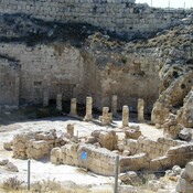
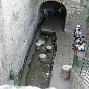
St. Helen the Constantine’s mother,  began to build up the Basilica in 326. It was completed around 330 and dedicated in 339. In 529 the Constantinian Basilica was destroyed during the Samaritan Revolt. In 531 it was rebuilt by Justinian as St. Mary Theotokos.

See:

  1. Lorenzo Nigro, Bethlehem in the Bronze and Iron Ages,  in the light of recent discoveries by the Palestinian MOTA-DACH, Vicino Oriente XIX (2015), p.10 - https://www.academia.edu/22280922
  2. http://www.bethlehem.custodia.org/default.asp?id=455

Nearby

Deir er Rawat

Deir er-Ra’wat.

Beit Sahur

Beit Sahur - biblical site.

Bethlehem, Milk Grotto (1 km)

Chapel of the Milk Grotto.


This object was added by Elżbieta on 2017-04-08. Last update by Elżbieta on 2018-06-14. Persistent URI: http://vici.org/vici/40794 . Download as RDF/XML, GeoJSON, KML.
Annotation available using the Creative Commons Attribution-ShareAlike 3.0 Unported license. Metadata available using the Creative Commons Public Domain Dedication, unless it is explicitly stated otherwise.

Vici.org partners:

Livius.org: articles on ancient history   Rijksmuseum van Oudheden