Il n'y a pas une annotation en français. Présenté est une annotation en Anglais.
Aqueduct that delivered water from local rivers direct to the minehead.
Sources:


Aqueduct that delivered water from local rivers direct to the minehead.
Sources:
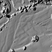
Aqueduct that delivered water from local rivers direct to the minehead.
Sources:
Ogofau Gold Mine, are Roman mines
Pumsaint Mining Settlement
Pumpsaint Thermae