Vici.org
Er zijn nog geen afbeeldingen met betrekking tot deze plaats toegevoegd.
Afbeelding toevoegen.

Omgeving:

Flint Mines at Cissbury RingPlan of CissburyChanctonbury Ring

Locatie:

  • Verenigd Koninkrijk, Findon
  • geo:50.860874,-0.381938
  • Locatie precies

Classificatie:

  • Fort
  • Zichtbaar

Identifiers:

  • vici:place=34297

Annotaties

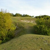
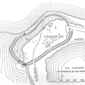
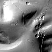
Middle Iron-Age fortified site possibly around 250 BC and abandoned in the period 50 BC - 50 AD.

Sources:

  1. https://www.ucl.ac.uk/archaeologyse/case-studies/cissbury-hill

In de buurt

Cissbury Ring

Flint mine

Chanctonbury Ring Temples (3 km)

Two temples

Chanctonbury Ring (3 km)

Chanctonbury Ring is a hill fort based ring of trees atop Chanctonbury Hill on the So.uth Downs


Dit object is toegevoegd door Elżbieta op 2017-01-19. Laatst bewerkt door Elżbieta op 2017-01-19. Persistent URI: http://vici.org/vici/34297 . Download als RDF/XML, GeoJSON, KML.
Annotatie beschikbaar onder de Creative Commons Naamsvermelding-GelijkDelen 3.0 Unported-licentie. Metadata beschikbaar onder de Creative Commons Publiek Domein Verklaring, tenzij expliciet anders aangegeven.

Vici.org partners:

Livius.org: articles on ancient history   Rijksmuseum van Oudheden