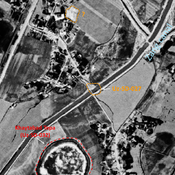
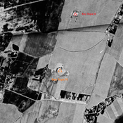
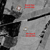
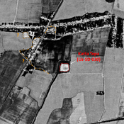
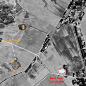
Vici.org

Umgebung:

UZB-SD_1970_AS 027 (Yangi Haytobod)UZB_SD_1970_Corona image_Bay Tepa IV (destroyed)UZB-SD_1970_Bay Tepa III 247UZB-SD_1970_Katta Tepa 030UZB-SD_1970_AS 026 (Oqjar)UZB-SD_1970_Yalpak Tepa 033

Lage:

  • Usbekistan, Yangi Haytobod
  • geo:37.56443,67.447731
  • Lage ± 0-5 m.

Period or year:

  • -5xx / 12xx

Klassification:

  • Stadt
  • Sichtbar

Identifiers:

  • vici:place=31782

Anmerkungen

Es gibt noch keine deutschsprachige Anmerkungen. Präsentiert wirden Anmerkungen auf English.

HAVLIK J., BOBIK J., DEDKOVA V., PARALOVO E. et al. (2023), A systematic archaeological survey in the environs of Khaytabad Tepa (Southern Uzbekistan). Preliminary report on the 2021 pilot season. Studia Hercynia XXVI-2 ( https://www.researchgate.net/publication/367965489_A_systematic_archaeological_survey_in_the_environs_of_Khaytabad_Tepa_Southern_Uzbekistan_Preliminary_report_on_the_2021_pilot_season )

STRIDE, S. (2004), La Géographie archéologique de la province du Surkhan Darya (Bactriane du Nord, Ouzbekistan du Sud). Unpublished dissertation at the Université panthéon-Sorbonne (Paris), 5 vols. ( https://sirisacademic.academia.edu/SebastianStride?swp=tc-au-44230952 )


In der Nähe

Anonymous site (Uz-SD-027)

Pre-Mongol and Post-Mongol medieval settlement. Completely destroyed after the digging of the Zang canal, but still partially visible on Corona imagery (1970). Studied by Arshavskaja & Rtveladze.

Unidentified site (1 km)

Probable archaeological site. Rectangular mound, visible on Corona imagery (1970), since leveled.

Anonymous settlement (2 km)

Former tepa, destroyed by ploughing in the second half of the 22th c. No dating information.