

Es gibt noch keine deutschsprachige Anmerkungen. Präsentiert wirden Anmerkungen auf English.
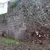
The town grew around the legionary fortress, which was abandoned in the early 70's. It became the Civitates for the Dumnonii. About 180 the town erected a stone wall. The structure was added to in the mediaeval times, but significant portions of it suvive.
http://roman-britain.co.uk/places/isca_dumnoniorum.htm
http://demolition-exeter.blogspot.com/2010/10/exeters-city-wall-2.html
http://www2.rgzm.de/transformation/unitedKingdom/Towns/Pic48.htm