

Es gibt noch keine deutschsprachige Anmerkungen. Präsentiert wirden Anmerkungen auf English.
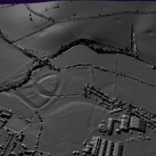
A walled town on Ryknild Street that was probably Alauna.. The extra mural settlement extended several hundred meters south of the town wall. Recent archaeolgical work clearly shows the jog in the road intersections.
http://roman-britain.co.uk/places/alcester.htm
http://www2.rgzm.de/transformation/unitedkingdom/smalltowns/Img24.htm