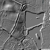
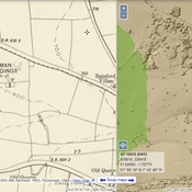
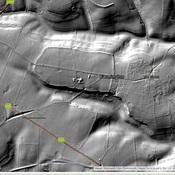
Vici.org
No images available yet. Please add images related to this place.

Surroundings:

Salmonsbury CampStow on the WoldNorbury camp

Location:

  • United Kingdom of Great Britain and Northern Ireland, Bourton on the Water
  • geo:51.886166,-1.768027
  • Location ± 25-100 m.

Class:

  • Rural settlement
  • visible

Identifiers:

  • vici:place=27667

Annotations


Nearby

Milestone

MILESTONE BESIDE A429 (WEST SIDE) ABOUT 350 METRES SOUTH WEST OF TURNING TO BOURTON ON THE WATER

Salmonsbury Camp (1 km)

Iron Age fortified enclosure known as Salmonsbury Camp

Chessels Roman site (2 km)

Chessels Roman site


This object was added by Randal Gilbert on 2016-06-19. Last update by Randal Gilbert on 2016-07-07. Persistent URI: http://vici.org/vici/27667 . Download as RDF/XML, KML.
Annotation available using the Creative Commons Attribution-ShareAlike 3.0 Unported license. Metadata available using the Creative Commons Public Domain Dedication, unless it is explicitly stated otherwise.

Vici.org partners:

Livius.org: articles on ancient history   Rijksmuseum van Oudheden