Il n'y a pas une annotation en français. Présenté est une annotation en Anglais.
Hadrian’s Wall, Vallum or Fosse
Segment XVI
Vxelodvnvm to Aballava
Stanwix to Burgh-by-Sands
Mile Castles: 66 -73
Built: after 128, dating uncertain
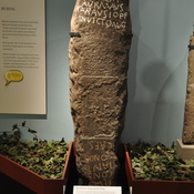
What is commonly called the “Vallum” was a wide ditch flanked by earthen ramparts that ran behind Hadrians wall. Its purpose remains uncertain as it is unique to Roman border fortifications. Possibly it was to define the military zone of the wall and to force trade and transport to follow marked roads to gates in the wall. In many places, it is more visible than the wall itself. The Wall corssed the river Eden on a bridge, and the Vallum has been overbuilt and destroyed by railroad construction for some distance on the south side of the river.
See: http://structuralarchaeology.blogspot.com/2010/11/40-reverse-engineering-vallum.html
https://en.wikipedia.org/wiki/Vallum_(Hadrian%27s_Wall)
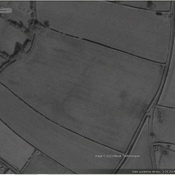
Hadrian’s Wall, Vallum or Fosse
Segment XVI
Vxelodvnvm to Aballava
Stanwix to Burgh-by-Sands
Mile Castles: 66 -73
Built: after 128, dating uncertain
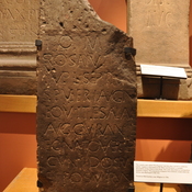
What is commonly called the “Vallum” was a wide ditch flanked by earthen ramparts that ran behind Hadrians wall. Its purpose remains uncertain as it is unique to Roman border fortifications. Possibly it was to define the military zone of the wall and to force trade and transport to follow marked roads to gates in the wall. In many places, it is more visible than the wall itself. The Wall corssed the river Eden on a bridge, and the Vallum has been overbuilt and destroyed by railroad construction for some distance on the south side of the river.
See: http://structuralarchaeology.blogspot.com/2010/11/40-reverse-engineering-vallum.html
https://en.wikipedia.org/wiki/Vallum_(Hadrian%27s_Wall)