

Es gibt noch keine deutschsprachige Anmerkungen. Präsentiert wirden Anmerkungen auf English.
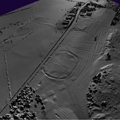
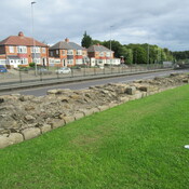
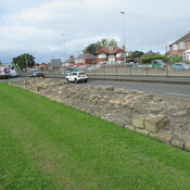
Hadrian’s Wall, Vallum Aelium, Vallum Hadriani
Segments IV - V
Vindobala to Onnvm
Rudchester to Halton Chesters
Mile Castles: 13 -22
Built: 122-128
Segment Length: 7,2 miles, 11.6 km
Mile Castles and turrets whose location and size can be documented are shown in outline form.
See: http://www.northofthetyne.co.uk/HWC4.html
http://www.northofthetyne.co.uk/HWC5.html
https://en.wikipedia.org/wiki/Hadrian%27s_Wall
http://structuralarchaeology.blogspot.com/2010/11/40-reverse-engineering-vallum.html