
, pl. IXb")

Es gibt noch keine deutschsprachige Anmerkungen. Präsentiert wirden Anmerkungen auf English.
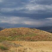
Kerti Hüyük lies 3.5 km north of Ekinözü Village; northeast of Karaman Province.
After discovered in 1956 inscription on the stone Kerti Hüyük is considered the most likely Derbe.1
The mound yielded potsherds belonging to Bronze Age, Hellenistic, Roman and Byzantine Period.
Sources:
- Michael Ballance, The Site of Derbe: A New Inscription, Anatolian Studies Vol. 7 (1957), pp. 147-151
- https://www.bibleplaces.com/derbelystra/
- http://www.tayproject.org/TAYages.fm$Retrieve?CagNo=4041&html=ages_detail_e.html&layout=web
Referenzen
- ↑ Michael Ballance, The Site of Derbe: A New Inscription, Anatolian Studies Vol. 7 (1957), pp. 147-151