Vici.org
No images available yet. Please add images related to this place.

Surroundings:

Qalaat Jaabar

Location:

  • Syrian Arab Republic, Ḩurayjat Jaḩsh
  • geo:35.903545,38.384197
  • Location ± 0-5 m.

Period or year:

  • -1400~ / -1200~

Class:

  • Castle
  • visible

Identifiers:

  • vici:place=23298

Annotations

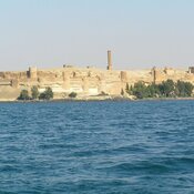
Tell Fray (T 532) was a Late Bronze Age town, dates to the XIV century BC and was destroyed by the fire in XIII cent, BC. The site is identified with ancient Yakharisha {Jahariååa or Iaharisa). Nowadays beneath the waters of Lake Assad.

Sources:

  1. Adnan Bounni: "Découvertes archéologiques récentes en Syrie", Comptes-rendus des séances de l'année - Académie des inscriptions et belles-lettres (in French), 132 (2): 1988, pp. 361–380
  2. Tony J. Wilkinson,  On the margin of the Euphrates. Settlement and land use at Tell es-Sweyhat and in the upper Lake Assad region, Oriental Institute Publications, vol. 124, Chicago: Oriental Institute, 2004 https://oi.uchicago.edu/sites/oi.uchicago.edu/files/uploads/shared/docs/OIP124.pdf

Nearby

Tell Abu Hureyra (4 km)

Remains of the Epipaleolithic and Neolithic settlements. Actually drowned beneath the waters of Lake Assad.

Qalaat Jaabar (Dausara) (8 km)

Arab castle Qalaat Jaabar. Initially, the Roman fort Dausra.

Athis (18 km)

OmnesViae import TPPlace2596


This object was added by Elżbieta on 2015-11-09. Last update by Elżbieta on 2022-06-02. Persistent URI: http://vici.org/vici/23298 . Download as RDF/XML, KML.
Annotation available using the Creative Commons Attribution-ShareAlike 3.0 Unported license. Metadata available using the Creative Commons Public Domain Dedication, unless it is explicitly stated otherwise.

Vici.org partners:

Livius.org: articles on ancient history   Rijksmuseum van Oudheden