Il n'y a pas une annotation en français. Présenté est une annotation en Anglais.
http://arheoparkbrazda.mk/archaeo/the-project/
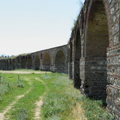
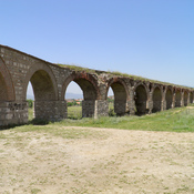
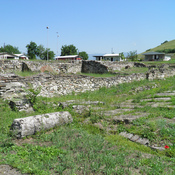
Brazda lies 10 km north from the center of Skopje in the south-west foothill of the Skopska Crna Gora mountain. South-west of the village, a separated hill “Gradište” rises high above the surrounding area. The northern and the western slopes are very steep, and on the south and east side the terrain steeply descends downwards. At the northern foot of the hill the rivers Brazda and Gluška (Čučerska) meet. These waters were captivated in roman times and supplied the ancient city Skupi and medieval Skopje with drinking water.
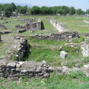
The remains of a fortified early antique settlement (5th-4th century B.C. ) can be found on the southern and western slope of the flattened top of Gradište hill, it is deployed in several terraces, on the surface of 4.5 Ha. It was a time when the most northern Paionian tribe Agrians lived in the region, but the type and nature of the excavated ceramic findings triggered a theory that Gradište was populated by Athenians who explored the rich natural resources of the environment.
At the northern foothill in 1986 a monumental structure was found, which according to researchers represents a tomb of a local royalty. This is confirmed primarily by its size, also by the quality of construction and the processing of the blocks, for which the most qualified architects were engaged.
The tomb is dug deep in solid rock, it has a rectangular room or chamber and an entrance with six steps on the south wall. There is a long access corridor (dromos), which steeply descends the slope of the hill and leads to the entrance. The walls of the chamber are made of nicely shaped travertine stone blocks of different sizes. The estimated weight ranges from 500 to 1500 kg. and it is assumed that they were carried from the stone quarry in the village of Gorno Svilare which is located 23 km from this location. The blocks are placed on top of each other in horizontal arrays. The front size of each block was relief staged and framed with smooth frame on the edges.
Ivanovic, R., 2013, "The First Archaeological Park in Macedonia - Arheo Park Brazda", Haemus Journal, vol. 2, 145-151, ISSN: 1857- 8411
Koracevic, D., 1977, "Наод од халштатско време од Бразда кај Скопје", МАА 3, 57-65
Микулчиќ, И., Соколовска, В., 1990, “Гробницата во Бразда”, МАА 11, 79-91
Sanev, G. 2013, "Red-Figure Vases in R. Macedonia" - Revue archéologique1, page 3 / 226
http://arheoparkbrazda.mk/archaeo/the-project/
Brazda lies 10 km north from the center of Skopje in the south-west foothill of the Skopska Crna Gora mountain. South-west of the village, a separated hill “Gradište” rises high above the surrounding area. The northern and the western slopes are very steep, and on the south and east side the terrain steeply descends downwards. At the northern foot of the hill the rivers Brazda and Gluška (Čučerska) meet. These waters were captivated in roman times and supplied the ancient city Skupi and medieval Skopje with drinking water.
The remains of a fortified early antique settlement (5th-4th century B.C. ) can be found on the southern and western slope of the flattened top of Gradište hill, it is deployed in several terraces, on the surface of 4.5 Ha. It was a time when the most northern Paionian tribe Agrians lived in the region, but the type and nature of the excavated ceramic findings triggered a theory that Gradište was populated by Athenians who explored the rich natural resources of the environment.
At the northern foothill in 1986 a monumental structure was found, which according to researchers represents a tomb of a local royalty. This is confirmed primarily by its size, also by the quality of construction and the processing of the blocks, for which the most qualified architects were engaged.
The tomb is dug deep in solid rock, it has a rectangular room or chamber and an entrance with six steps on the south wall. There is a long access corridor (dromos), which steeply descends the slope of the hill and leads to the entrance. The walls of the chamber are made of nicely shaped travertine stone blocks of different sizes. The estimated weight ranges from 500 to 1500 kg. and it is assumed that they were carried from the stone quarry in the village of Gorno Svilare which is located 23 km from this location. The blocks are placed on top of each other in horizontal arrays. The front size of each block was relief staged and framed with smooth frame on the edges.
Ivanovic, R., 2013, "The First Archaeological Park in Macedonia - Arheo Park Brazda", Haemus Journal, vol. 2, 145-151, ISSN: 1857- 8411
Koracevic, D., 1977, "Наод од халштатско време од Бразда кај Скопје", МАА 3, 57-65
Микулчиќ, И., Соколовска, В., 1990, “Гробницата во Бразда”, МАА 11, 79-91
Sanev, G. 2013, "Red-Figure Vases in R. Macedonia" - Revue archéologique1, page 3 / 226